Lower & central Belmont
Convenient access to Caltrain, El Camino Real, Twin Pines Park, civic facilities, and the evolving Belmont Village area. Street position and traffic exposure still matter.
Central · Belmont Village · Sunnyslope · DowntownBelmont community guide
A city shaped by topography
Belmont sits midway between San Francisco and San Jose. The City describes a quiet residential community known for wooded hills, San Francisco Bay views, and stretches of open space.
Those qualities are inseparable from the real-estate story. A lower-elevation home near Caltrain, a mid-hill residence with a usable yard, and a ridge property with an expansive outlook may attract very different buyers.
“In Belmont, the land and approach can matter as much as the house.”
Market perspective
Belmont’s micro-markets can diverge quickly. Pricing should begin with the closest competitive experience—not simply the nearest sale or the same square footage.
Neighborhood orientation
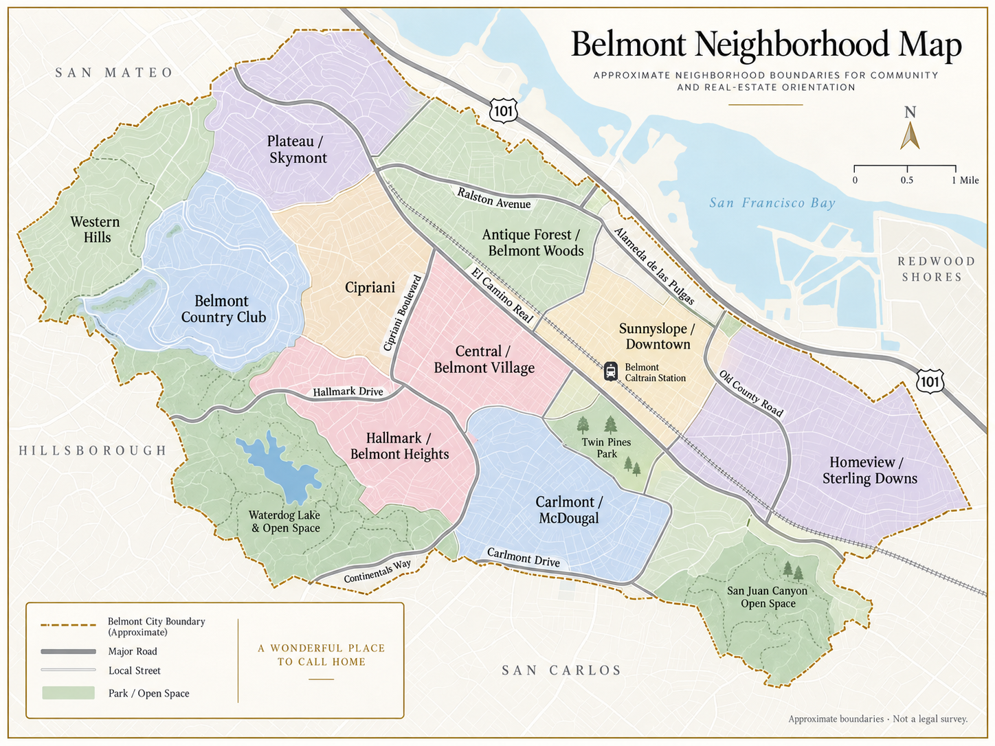
Belmont’s neighborhood names come from City-recognized groups, common local usage, and real-estate practice. The map is designed for orientation; exact legal, parcel, HOA, and school boundaries must be verified independently.
Convenient access to Caltrain, El Camino Real, Twin Pines Park, civic facilities, and the evolving Belmont Village area. Street position and traffic exposure still matter.
Central · Belmont Village · Sunnyslope · DowntownA broad mix of ranch, split-level, traditional, and updated homes, with terrain and outlook changing quickly from one street to the next.
Cipriani · Antique Forest · Belmont Woods · Carlmont · McDougalViews, privacy, mature trees, and hillside settings can be major advantages. Lot usability, access, drainage, and renovation quality remain property-specific.
Belmont Country Club · Plateau · Skymont · Hallmark · Belmont HeightsA stronger natural setting comes with more complex questions about slope, geology, access, infrastructure, environmental constraints, and development feasibility.
Western Hills · Waterdog Lake · San Juan CanyonHillside ownership
The City specifically cautions prospective buyers in San Juan Hills and Western Hills about possible steep slopes, geologic hazards, limited access and infrastructure, environmental protections, and special planning requirements.
Slope, drainage, retaining walls, trees, foundation history, and usable outdoor space can materially change the ownership experience.
Road width, driveway grade, parking, utilities, and emergency access deserve property-specific review.
Confirm zoning, permits, parcel history, and realistic development feasibility before paying for expansion or build potential.
Life in Belmont
Trails and open space give western Belmont a strong outdoor identity and a sense of retreat.
A central civic setting near City Hall, community facilities, picnic areas, and short walking paths.
The El Camino Real and 5th Avenue area connects transit, services, housing, and ongoing placemaking.
Belmont’s station provides a direct rail connection along the Peninsula corridor.
Carlmont Village and businesses along Ralston Avenue and El Camino support everyday needs.
Highway 101 anchors the eastern side, while Ralston Avenue connects the lower city with the hills and routes toward I-280.
Public schools
Enrollment policies and assignments can change. Buyers should use official district resources rather than relying on a listing or neighborhood map.
Belmont campuses include Central, Cipriani, Fox, Nesbit, and Ralston. The district manages enrollment and assignment centrally.
Confirm current enrollment rules directly with BRSSDCarlmont is located in Belmont and is part of Sequoia Union High School District. Families should verify current attendance and enrollment information with the district.
Use current SUHSD assignment resourcesShiraz’s seller perspective
The strongest Belmont presentation explains the view, light, lot usability, outdoor experience, access, and improvements clearly, then positions the property for the buyers most likely to value those advantages.
Discuss your Belmont homeTopography can change views, privacy, access, lot usability, and development potential within a short distance. Exact street, condition, architecture, outdoor space, and proximity to transit or open space also affect the buyer pool.
The map combines City-recognized neighborhood groups with customary real-estate area names. Boundaries overlap and vary, so it is an orientation guide—not a legal, parcel, school, or association map.
Review slope and geology, drainage, retaining walls, foundation history, driveway and emergency access, trees, insurance, permits, and the feasibility of future work. Vacant or lightly improved parcels in Western Hills and San Juan Hills require especially careful City review.
Yes. Belmont has a Caltrain station on El Camino Real. Buyers should check current schedules, service levels, and first/last-mile options directly with Caltrain and local transit providers.
Belmont-Redwood Shores School District manages TK–8 enrollment, and Carlmont High School is within Sequoia Union High School District. Verify placement, boundaries, and enrollment policies directly for the exact address.
Start with homes that offer a similar elevation, outlook, lot usability, access, condition, and buyer experience. A citywide average is context—not a substitute for property-specific analysis.
Considering Belmont?
For a confidential Belmont buying or selling conversation, contact Shiraz Zack.
Call (650) 245-4915Information was reviewed September 2026 using City of Belmont, Belmont-Redwood Shores School District, Carlmont High School, and Caltrain sources. Area descriptions are original summaries. The supplied map is an approximate orientation guide, not an official or legal survey. Buyers should independently verify boundaries, school placement, permits, slope and geologic conditions, insurance, property condition, and other facts important to their decision.